Tuesday, July 30, 2013

St. Jonsfjorden


Our first field day was supposed to take place in Poolepynten.  Most unfortunately, Poolepynten was completed shrouded in cloud base.  We went with Plan B, and headed to St. Jonsfjorden.  This delayed our field work by about an hour.  Here is where we headed:


When we arrived in St Jonsfjorden, I did something that I have actually never done before.  I worked an entire field day in the rain.


This was before the steady downpour began.  Thankfully, I borrowed rain pants from a friend before departing to Svalbard.  Rain pants are essential in the Arctic.  I also went ahead and bought some new field pants in Longyearbyen before we left for the cruise.  While the field work that we do in UH undergrad is (in my opinion) really fantastic, Texas and Montana field camps do not really prepare you for Arctic cold.  Just walking to classes in Longyearbyen was enough for me to realize that my usual desert field pants were not going to cut it.  I also rarely drank from my usual water bladder – each student carried a thermos with hot tea or coffee in it. 

My group was tasked with mapping and sectioning the southernmost moraines on St. Jonsfjorden.  Yuribia was part of the reporting group – she and her members used a theodolite to create a vertical profile across the raised beaches. 

The picture is slightly blurry because my camera lens was coated with water from all the rain.  We mapped the moraines using GPS waypoints, and discovered what may be a drumlin!

           
It’s the drumstick shaped landform in the southwestern corner.  Usually, moraines mark the limits of a glacier, laterally or terminally.  In the case of this area, however, properly callied Piriepynten, it is likely that the moraines are push moraines – they are essentially shoved up onto the beach from a previously advanced glacier.  Now that the glacier has retreated, these push moraines are left as relict positions marking glacial extent.  It is very cool to see the landscape in action.  Our field day ended earlier than expected, due to the uncomfortable rain conditions.  Sadly, due to the low cloud base, we were not able to see the actual glacier (Gunnarbreen, I think) while we were in the field.  We saw it hours later, as the boat was roaring away.  This beautiful view was behind us the whole time!
 

Monday, July 29, 2013

The Cruise Begins...

We’re back.


Yuribia, myself, and the rest of AG-332 have just returned from an eight-day cruise.  We set sail on the Stålbas on Sunday, July 21st.   I will make one post for each major field site, in the order in which they were visited.  But first, we’ll need some logistics.  This is the Stålbas.

She’s very pretty.  My advisor and I returned from a 33 day cruise aboard the R/V Araon on May 18th.  The Araon is quite likely one of the largest research vessels around right now.  Consequently, I am used to being aboard quite a large ship, and was thus rather unprepared for the seasickness that a smaller vessel can cause.  I am definitely not a hardy seawoman.  When the ship started to pitch in the waves (and oh, did she, though my shipmates would argue that wave heights of 4 meters are pitifully small), my roommate and I headed for the cabin to hide in our beds.
Liz took top bunk – I would have gotten a picture of my bunk too, but the cabins were more ship-sized than I was used to from the practically palatial staterooms on the Araon.  

After we set sail from Longyearbyen, our first view was a long stretch of the mountains bordering Isfjorden:


It’s gorgeous.  Isfjorden is one of the primary drainage outlets of Svalbard.  During the deglaciation of the Svalbard-Barents Sea ice sheet, the major western fjords (Isfjorden, Kongsfjorden, and Bellsund) were massive ice drainage basins for the sheet – basically, as the sheet melted, it used these fjords as channels through which to dump its ice and sediment.  If you look at a bathymetric map of Svalbard, you can see the evidence of these major ice streams in the trough mouth fans (TMF) that have accumulated at the edge of the previously grounded sheet.  Trough mouth fans are massive sediment fans that accumulate at the base of the previously grounded sheet.  They increase in size as you go south, meaning that Isfjorden is the second largest.


I should be starting our field blog tour with Linnedalen, but weather prevented us from visiting this site.  It did not, however, prevent us from seeing walruses.


They’re loud and huge.

Final logistics.  Our class is on a boat.  How to get into the field?
Zodiacs.  Below deck, we would put on our survival suits.  When we are successfully looking like giant orange lobsters, we go up deck and put our stuff into a small orange boat attached to the side of the ship.  This one:


This boat lowers us down into the water, where we move into the actual zodiac and zoom out to land.


It takes three trips to get all of us on shore.  Three trips back.  For me, the trip usually was shorter than actually getting into the survival suit. 

Thursday, July 25, 2013

Jen's first from field


I have arrived!

After more than 24 hours travelling, I am in Longyearbyen, Svalbard.  My home is Barrack 3, and I am right across the hall from Yuribia.


I arrived at 1 am in the midnight sun and cold rain.  The sun sneaks around the mountains outside my window.   I love this ever-present sun for every minute right up until I have to go to sleep.  Then I get annoyed that it won’t go down.  We’re getting on better terms now that I have taped the window curtains to the wall (geo-tip: never forget to pack tape).

Yuribia and I are both enrolled in AG332 – Arctic Terrestrial Quaternary Stratigraphy.  We are studying with eleven other glacial students from Canada, USA, Norway, Denmark, Poland, Germany, and Iceland.  We began the course with rifle safety training.


My first round of shots was much better, but I didn't think to take a picture of it =(

Here is someone who lives nearby.  I see him every morning.


We have completed three days of seminar classes, including a presentation given by the students on an assigned topic (mine was "Seafloor fingerprints of the Svalbard-Barents Sea deglaciation", Yuribia's was "Glacial History of Kongsfjorden").  We are scheduled to leave for our cruise on the Stalbas tomorrow morning at 9 am, for nine days of stratigraphic fieldwork.  We are spending today packing and watching the rain.  It is quite cold, but very very beautiful.  Here is the view of Longyearbeen glacier from my front porch.


And one last picture of Yuribia and Liz, an American student from the University of Buffalo, in Longyearbyen.


Packing for the Field

I'm Jen Campo.  And I'm currently sitting in my Houston office, where the temperature outside is listed as 91F, but I'm pretty sure that's an underestimation.  In five days, I'll be walking about 3 kilometers from my dorm to the University Centre in Svalbard (part of the University of Norway) in 40F.  And the sun will never set.

I'm headed off to meet my labmate, Yuribia -- she's been in Svalbard for a month already.  We'll be taking the same class this July -- Arctic Terrestrial Quaternary Stratigraphy.  And there is an 8 day field excursion.  I am very excited, and also very lucky.  This past May, I returned to Houston after 33 days in Antarctica.

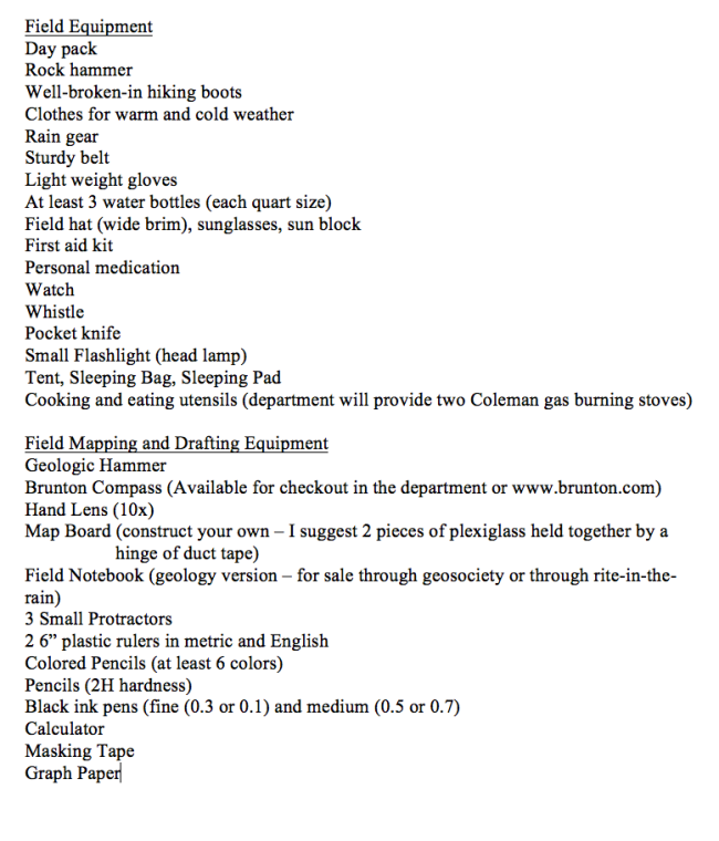
This post is about packing for the field.  It's something that I really wish someone had explained to me prior to my first field trip to Inks Lake in 2011.  I had zero camping experience before I began my geology major, and this is the field list that you get at the beginning of Field Methods at UH.

Image
This is a great list of field equipment, if you know what you're doing.  I, however, did not, and so I took "Day Pack" to mean backpack that holds your tent, sleeping bag, tools, clothes, etc...and that's how I showed up to Inks Lake.  I completed my first foray of field work with a backpack the size of a ten year old kid.  It was slow, hot, and it took my attention off of the job at hand because I was so mad at how badly I'd misinterpreted "Day Pack" (so mad, that I have no pictures of said travesty, as I couldn't reach my camera in the depths of my huge pack).  This was my biggest mistake in my early undergrad camping.

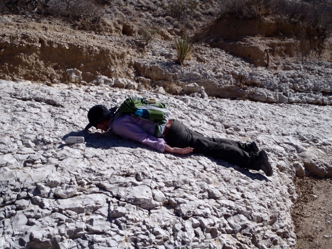
I now have the smallest backpack available.  Witness its tiny size!

Image

Four good field lessons can be taught just from this picture alone.  (1) Crucial small backpack, with only enough room for 2L water pack (skip the three water bottles and invest in a bladder that fits in your pack), one extra water bottle, lunch, sunscreen.  (2) Bring a cool hat, not a stupid one like I'm wearing.  (3) Long sleeved field sheets, preferably with some built-in UPF protection (Magellan and Columbia are good brands) are key, and (4) If you intend to plank, don't do it on something flat because it won't count and people will continue to remind you of this years later.

For week long field trips conducted through your geology department, that list is perfectly comprehensive.  If you're going to the desert, you'll need tweezers.  Don't forget essentials like duct tape (to fix a mapboard), masking tape (to tape down maps in windy areas), and chapstick.
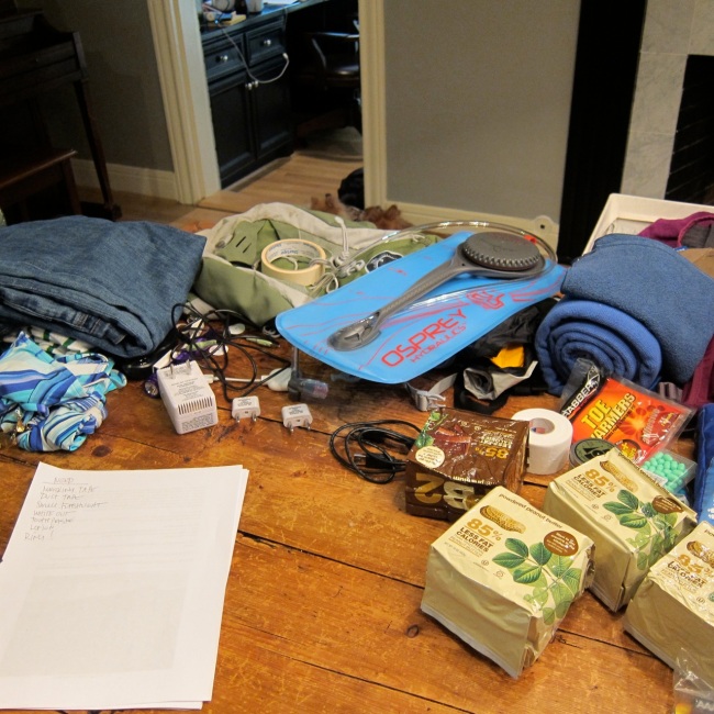
Is your field work out of the country?  For more than 4 weeks?  You need...really not that much else.  Passport and adapters.  That's the only extras.  Here is what I'm packing for Svalbard, which serves as a good corollary to what you should pack for something like field camp.

Image

Don't forget your own towel.  No one is going to let you borrow theirs.

Adapters and transformers are super important for foreign travel, but perhaps more important for domestic and foreign travel is the AUX cable, with inputs at both ends.  How else will you control the music in the van you are riding in, or the car you may have to rent if you end up with two free days in Chile, for example?  On that note, if you are traveling out of the country, bring your driver's license in addition to your passport.  You never know when you may need to rent a car.  Also, know how to drive stick.  Really.

Bathing suits always come in handy.  One thing I'd wish I'd known prior to field camp was that it behooves one to have some "going out" clothes, like jeans.  This lack of information meant that every night spent out in town was done so in my dirty field clothes.  Lame.  You will also need peanut butter.  Lots of it.  Reconstituted is easier to pack, fresh easier to buy onsite, and I have learned the importance of having your own food stash on long trips.  If you are packing your own food and traveling into a different country, prepackaged is the only type of food that you will be allowed to take through customs in most places.

Image

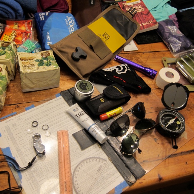
Yes, this picture is shamelessly posed.  Note the broken hand lens.  Yours should be in fine working order for the field, and you should always be using it!  I like to bring multiple sunglasses, in case I break a pair.  I once briefly stole someone's sunglasses on accident for an entire morning -- another reason to have a backup.  Accidental thieves may be among you!

Are your hands prone to dryness and cracking?  You're not sure?  Take ClimbOn! with you.  It's a life saver.  You can't really see the little field pack I have to hold my notebook, but it's great and fits on my belt (a present from Nikki after I broke my first one and then whined about it for an afternoon).  The small flashlight is more appropriate for boat-based field work.  You never know what can happen at sea!  Leatherman tools are OK, but heavy.  Don't leave for any fieldwork without your headlamp (not pictured here, because it's the first thing I put in my bag).  Speaking of bags, don't bring a suitcase!  EVER!  Learn to pack a duffel.
My map board has held up for two and a half years -- it should fit behind the space between your lower back and backpack.  That is how you should carry it.  You don't want to waste time packing it away in your backpack over and over again while you're out in the field.

What else to take?

Image

A cool hat!  My Alligator Queen hat has weathered many field trips.  Despite popular belief that you should change your shirt every day, the same is not true in the field.  If you have a week of field work, you need a max of two shirts.  More than a week, three.  Same for pants.  However, you should have a different pair of socks, with liners to prevent blisters, and underwear for EVERY day, otherwise...well...you will smell.

That ziploc bag is filled with earplugs -- an indispensable tool for sleep, in my opinion.  A puffy down jacket!  I learned this lesson the hard way.  Every day in Antarctica, I was cold.  I bought that jacket as soon as I stepped off the boat.  I wore it right up until the minute my plane landed in Houston (where it is sure to be useful for two, maybe three, days per year), and its one of the best investments I've ever made.  Even Texas spots, particularly Big Bend, can get very cold at night.  I distinctly recall being terribly jealous of another TA's awesome, puffy coat this past February at Inks Lake.  The stowaway dog (unfortunately, dogs are not allowed on field trips -- Bo in Montana is the only exception) is sitting on my rain coat, borrowed rain pants, and three base layers.  Cold weather work is all about the layers.  Waterproof case for my phone and camera -- this is really only important if you are doing zodiac (rubber boats that take you from the ship to the shoreline) work.

Not pictured or listed, but still important.  Shower shoes!  Hand sanitizer for the field.  Gum and/or tic-tacs (field breath is uncomfortable, for you and whomever you are speaking to).  Durable camera.  Your own coffee.  A good knife.  Compton, if you have room.  For work >3 weeks, toenail clippers.  Seriously.  A small hair dryer. 

In reference to the field equipment list posted above, you're not going to need a calculator or graph paper.  And three small protractors means these guys (4 inch).  I still carry a whistle, but I've never used it.  Don't bother bringing your hammer to Inks Lake or Big Bend -- you won't be able to use it inside state or national parks. 

Most important lessons learned over six departmental field trips (four involving stays in tents ranging from one to five nights), one session of field camp (five weeks), and one research cruise to Antarctica involving a five day stay in Punta Arenas, Chile:

Do not overpack.  That is all.  

Happy packing!

Wednesday, July 17, 2013

July 17, 2013 - Week 4: Last week of class

This week was relatively short in terms of class time and field work, in fact we only went out to the field in one occasion. On Monday we had a short review of fluvial deposits and an introduction to deep-water deposits. We also discussed the similarities and differences between river, turbidite, debris flows, and hyperpycnal flow channels since they may look somewhat similar in map view but in detail they could be quite different. This reflects the differences in depositional environments and sediment sources.

View of Honaskogdalen, most of the lower areas are covered by moss or grass since the snow has melted but in some higher areas there are still patches of snow.  

Walking on rock fall and debris flows on the slopes of Honaskogdalen.

During our only day out in the field we visited Honaskogdalen, a fjord valley located about 7 km north of Longyearbyen. The walk to the outcrop area was long; it took us over an hour of walking to reach the outcrops we were studying. I was surprised to see that there was still snow in some of the channels and ravines, since it is July, but evidently much less snow than there was during our first day out in the field. Again we were divided into groups and given a certain area to map and create a stratigraphic column, and then we had to correlate our columns to interpret the depositional environment. The formation of interest is called Helvetiafjellet from the lower Cretaceous and consists of fluvial, deltaic, and tidal deposits representing an overall transgressive pattern. We were advised by our instructor to take pictures of the whole area and pinpoint in our drawings where we did the stratigraphic columns because correlating could be difficult after leaving the study area. The next day we realized she was right.

Wednesday was a short seminar day. The main goal for the day was to correlate all the stratigraphic columns and discuss our observations in the field.  The groups found coal seams, mud drapes, thick massive sandstone bodies, ripples, and dunes as well as parallel bedding. All of these agree with the environment of deposition expected but our main problem was agreeing on the correlation of our columns. Something we agreed on was the presence of several channels, which may explain why the deposits are different even if they are close to one another. Thursday was “reading day”, which we used to study for our final (comprehensive) exam on Friday.
Students at Sukkertoppen hill next to Longyearbyen, for a last hike together(me in the red jacket and jeans).

View from Sukkertoppen hill. Student dorms and Longyear glacier.
 
View of Longyearbyen from Sukkertoppen hill, UNIS is the marroon building in the center. Notice the brown sediment plumes coming from rivers draining glaciers and going into the blue fjord water.
 
Longyearbyen street, going from the sea towards Longyear glacier (on the background).


And just like any other class, this one also came to an end. I believe it was very rewarding, both academically and personally. I have gained perspective and experience on glaciated environments, which will be very useful since I live in the sub-tropics. Above all, the professors and fellow classmates were especially amazing and I am so grateful to have met them. 


July 17, 2013 - Week 3 in Svalbard


During this week, our class traveled to Svea located in Van Mijenfjord, southeast of Longyearbyen. Svea is a mining settlement, originally founded in the early 1900s by a Swedish mining company; in fact the name Svea is the old name for Sweden. The settlement accommodates people working in the mine or in the nearby facilities; approximately 300 people live there but no one stays permanently. Miners work shifts of 12 hours a day and live in the settlement since there is no public transportation in and out of Svea. The workers commute on a company-owned aircraft from Longyearbyen and stay for few days in Svea and then fly back home to Longyearbyen for a few days off.

We had two main goals in Svea, the first one was to look at glacial sediments deposited by Paula Glacier, a glacier that ends directly in the water of Van Mijenfjord and has experienced glacial surges since the last glacial maximum, approximately 20,000 years ago. A surge is a rapid event during which the glacier advances at fast velocities while “pushing” and depositing sediment at its front and flanks. The second goal was to study modern Arctic tidal deposits in Braganzavågen, an enclosed bay just east of Svea and connected to Van Mijenfjord by a short channel. The enclosed bay formed during the last glacial maximum when Paula glacier was far out into the fjord and formed an end moraine that blocked the exit of water from rivers coming into the bay, forming a dam lake.  Part of the end moraine is still there but water can get in and out of Braganzavågen since the glacier has retreated. The water depth is very shallow, close to 20cm deep, even shallower in some areas, and here is where tides come into effect since the tidal range is close to 2 m in this region.


View from the aircraft flying into Svea, which can be seen in the background. The photo shows the remains of the end moraine which separates Van Mijenfjord (on the left) from Braganzavågen (on the right).
 
Some of the buildings from Svea, in front of them is located the end moraine. The distance between the buildings and the end moraine is approximately 2km, where waters from Van Mijenfjord and Braganzavågen mix.
 
“Welcome to Svea” sign at airport. Miners use this airport several times a day to travel to and from Longyearbyen.  

 The invited lecturer for the week was Dr. Eiliv Larsen from the Geological Survey of Norway. He is an expert on arctic glacial deposits and geomorphology and has studied the Svea region. On Monday, we only had a short morning lecture on glaciers and their deposits, as well as a short introduction to the research area. The afternoon was used to pack for our trip and to get all the necessary equipment from UNIS.

On Tuesday morning we took a short flight, along with a few miners, to Svea. The flight was about 15 minutes long; it took more time to load the plane than the time we spent on the air. We arrived to a very small airport, with only one building and the control tower. UNIS rents a house that has been modified as dorms and this is where students and faculty stay when visiting Svea. In the afternoon, we drove around the area to get familiar with the geology of the region. The most impressive feature was Slak glacier that drains into Braganzavågen. Interestingly enough, the entry to the mine is right next to the glacier.


Student gear, sampling devices, shovels, and riffles to be used in the field.

The following day we ventured into the glacial deposits right next to Van Mijenfjord. The area is characterized by hummocky structures and the surface sediments have been interpreted as reworked marine sediments. We had an interesting discussion on some glacial deposits that present folding, which is possible because the deposits are very stiff due to the compression of ice. One of the hypotheses for the folding of the structure was ice coming from two different sources and therefore compressing the rigid deposits in two directions. 
Students and professors describing and discussing beach deposits, Braganzavågen on the background.


At the beach, coal fragments that have been carried by currents from the nearby mine. In the background, hummocky structure of glacial deposits with no vegetation cover.
 
Students describing intertidal bar deposits. This particular bar has not been covered by water in a long time since vegetation is currently growing on it while the surrounding channels are active. 

 
We spent Thursday all day walking on mud, which is harder than it sounds, especially if the mud reaches up to your knees; in Braganzavågen this is the case. We were divided into groups to study the different aspects of the tidal flat environment; tidal channel, intertidal bars, and supratidal bars. Relatively few studies on tidal systems in modern glaciated areas have been completed; surface ice, permafrost, and the minor (if any) biogenic activity are some of the features that differ from low latitude regions. The end product of our observations this day was a term paper in which we all worked over the weekend. Even with the limited time in the field area we were able to identify key features for tidal flat environments like mud drapes and sediment fining patterns. There were also a couple of interesting features in the area; algal mats, that look like wet, wrinkled paper, and superimposed ripples, these possibly formed by currents at 90° from each other creating a square net-like configuration on the surface of the intertidal bars.